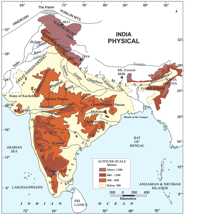
Physiographic Divisions in India
India is a country of great physical diversity. On basis of the varied physiographic features, India is divided into six physiographic divisions:
- Northern and North-eastern Mountain
- Northern Plain
- Peninsular Plateau
- Indian Desert
- Coastal Plains
- Islands
I. Northern and North-eastern Mountains
Structure:
The general orientation of the great Himalayas is from North-west to Southwest direction (in the Northwestern region). In Nagaland, Manipur, and Mizoram, the Himalayas are oriented in North-South direction.
Himalayas are physical as well as Climatic, drainage and cultural divide.
The sub-divisions of Himalayas:
Kashmir/Trans Himalayas:
Karakoram, Ladakh, Zaskar, Pir Panjal ranges. The North-Eastern Part of Kashmir Himalayas is Cold Desert between Greater Himalayas and Karakoram ranges. Kashmir valley lies between great Himalayas and Pir Panjal and Dal Lake. Karewa formations occur in the Kashmir valley, highly conducive to saffron cultivation of zafran variety. Freshwater lakes in Kashmir Himalayas are Dal and Wular lakes. Pangong Tso and Tso Moriri are the saltwater lakes. The rivers passing through this part of Himalayas are Jhelum, Chenab.
Himachal & Utaranchal Himalayas:
Between Ravi river in west and Kali river in the east, This part of Himalayas is drained by Indus and Ganga river systems. The Northernmost part of Himachal Himalayas is an extension of Ladakh cold desert, in Spiti sub-division of Lahul and Spiti. It consists of Great Himalayan, the Lesser Himalayas and Shiwalik range from north to south, locally called Dhauladhar in Himachal Pradesh and Nag Tibba in Uttarakhand. ‘Shiwalik’ and ‘Dun formations’ are features of this part of Himalayas. All five Prayags are located here.
Darjiling and Sikkim Himalayas:
It consists of Nepal Himalayas in the west and Bhutan Himalayas in east. Though this part is small but significant. Tista is the fast-flowing river here. Kanchenjunga peak (Kanchengiri) and deep valleys. Lepcha tribes in high up regions. This area is characterised by absence of Shiwalik formations. In place of them, there are ‘duar formations’ which are useful for tea garden development.
4. Arunachal Himalayas:
Absence of Shiwalik formations. From east of Bhutan Himalayas up to Diphu Pass in east. Direction of ranges is from southwest to northeast. Kangtu and Namcha Barwa are important mountain peaks. Brahmaputra flows through a deep gorge after crossing Namcha Barwa. This region is rich in biodiversity and is preserved by indigenous communities. No inter-valley transportation linkages due to rugged topography. Most interactions occur through duar region along Arunachal and Assam border.
5. Eastern Hills and Mountains:
They have their alignment from north to south. The Barak River flows in Manipur and Mizoram. Manipur has a large lake named as ‘Loktak’ at the centre, surrounded by mountains from all sides. Mizoram area is known as ‘Molassis Basin’ and is made up of soft unconsolidated deposits. Rivers in Nagaland form tributaries of the Brahmaputra. Barak river is a tributary of Meghna. Rivers in the eastern part of Manipur are tributaries of Chindwin, which is a tributary of the Irrawaddy in Myanmar.
II. Northern Plains Physiology of India:
They are formed by alluvial deposits brought by rivers – Indus, Ganga, Brahmaputra. The Northern Plains extend 3200 km from east to west in Indian physiography. The maximum depth of alluvial deposits ranges from 1000–2000 km.
Three zones from north to south –
Bhabar (narrow belt parallel to Shiwalik foothills at slope break-up),
Tarai (they are situated in south of Bhabar, re-emerge without having any properly demarcated channel, this region has luxurious growth of natural vegetation),
Alluvial Plains (located to the south of Tarai, mature stage of fluvial erosional and depositional landforms like sand bars, meanders. It is divided into Khadar and Bhangar).
III. Peninsular Plateau:
Oldest and most stable landmass of India, general elevation from west to east. Important physiographic features are tors, block mountains, rift valleys, spurs, bare rocky structures, series of hummocky hills, and wall-like quartzite dykes offering natural sites for water storage. The western and northwestern region has emphatic presence of black soil.
Peninsular plateau is extended till Jaisalmer in the west, where it is covered by longitudinal sand ridges and crescent-shaped sand dunes called Barchans.
Metamorphic chain history is marked by the presence of metamorphic rocks such as marble, slate, gneiss, etc.
The Peninsular Plateau is divided into three groups: Deccan Plateau, Central Highlands, and Northeastern Plateau.
The Central Highlands:
It extends from the Narmada River to the Northern Plains, bounded by the Aravalis in the west and the Satpura Range in the south. Malwa and Chhotanagpur Plateau are part of the Central Highlands. The eastern extension of the Central Highlands is formed by the Rajmahal Hills.
Deccan Plateau:
It is separated by a fault from the Chhotanagpur Plateau. The black soil area of the Deccan Plateau is known as the Deccan Trap, which is formed by volcanic activity and supports sugarcane and cotton cultivation. It includes the Western Ghats and Eastern Ghats. Both Ghats converge at the Nilgiri Hills.
Northeastern Plateau:
It is essentially an extension of the main Peninsular Plateau. It comprises the Meghalaya and Karbi Anglong Plateau, which are detached from the main block. The Meghalaya Plateau is divided into three parts – Garo Hills, Khasi Hills, and Jaintia Hills. The Meghalaya Plateau receives maximum rainfall and stands devoid of any permanent vegetation cover. It is also rich in mineral resources.
IV. Indian Desert:
The Indian Desert is located in the northwestern part of the Aravali Hills, also known as the Thar Desert. It is the ninth-largest desert in the world. The rainfall received is below 150 mm per year. The vegetation in the Thar is semi-arid with thorny bushes. The rivers are ephemeral, and only Luni is a significant river.
V. Coastal Plains:
The coastal plains in India are situated parallel to the Arabian Sea and Bay of Bengal. Based on location and active geomorphic processes, they are divided into the Western Coastal Plains and the Eastern Coastal Plains.
1. The Western Coastal Plain –
Extends from the Rann of Kachchh to Kanyakumari. It comprises four notable divisions:
- Kachchh and Kathiawar Coast in Gujarat
- Konkan Coast in Maharashtra
- Goan Coast in Karnataka
- Malabar Coast in Kerala (characterized by backwaters, locally known as ‘kayal’)
The western coast is narrow in the middle and becomes broader towards the north and south. The rivers along the Western Coast do not form deltas.
2. Eastern Coastal Plain –
This plain extends along the Bay of Bengal and is broader than its western counterpart. Being an emergent coastal plain, it has a limited number of ports and harbours. The Eastern Coast is known for its well-developed deltas formed by the Mahanadi, Godavari, Krishna, and Kaveri rivers. The continental shelf extends up to 500 km into the sea.
VI. The Islands in India:
Within the physiographic framework of India, there are two major island groups located in the Bay of Bengal and the Arabian Sea respectively.
The Bay of Bengal Island group consists of 204 islands, collectively known as the Andaman and Nicobar Islands. The Andaman Islands are located in the north, and the Nicobar Islands lie to the south; they are separated by the “Ten Degree Channel”. The coastline of these islands features coral deposits and picturesque beaches. This region supports equatorial vegetation.
The Arabian Sea Island group is referred to as the Lakshadweep and Minicoy Islands. These are situated close to the Malabar Coast and are composed entirely of coral deposits. Of the 43 islands, Minicoy is the largest.
The Island Chain of Andaman and Nicobar and Lakshadweep:
1) Lakshadweep:
Capital – Kavaratti (comprising 30+ islands)
This island chain is formed primarily of atolls, which are ring-shaped coral reefs encircling a lagoon.
It is separated from mainland India by the Laccadive Sea and from the Maldives by the Eight Degree Channel, which serves as a significant maritime boundary.
2) Andaman and Nicobar Islands:
Capital – Port Blair (comprising 356 islands)
This island chain consists of coral formations and submarine ridge systems, making it geologically significant.
It is separated from mainland India by the Bay of Bengal. The Andaman Islands and the Nicobar Islands are divided by the Ten Degree Channel. Furthermore, the South Andaman and Little Andaman islands are separated by the Duncan Passage, a crucial navigational route in the Indian Ocean.